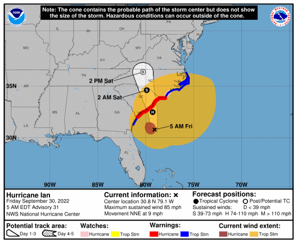
A revived Hurricane Ian lumbers toward South Carolina’s coast Friday and the historic city of Charleston, with forecasters predicting a storm surge and floods after the megastorm killed at least 21 people in Florida, washed countless homes out to sea and left 42,000 workers scrambling to restore power to as many as 2.6 million.
With all of South Carolina’s coast under a hurricane warning, a steady stream of vehicles left Charleston on Thursday, heeding officials’ warnings to seek higher ground. Storefronts were sandbagged to ward off high water levels in an area prone to inundation.
Along the Battery area at the southern tip of the 350-year-old city’s peninsula, locals and tourists took selfies against the choppy backdrop of whitecaps in Charleston Harbor as palm trees bent in gusty wind.
With winds holding at 85 mph, the National Hurricane Center’s update at 5 a.m. Friday placed Ian about 145 miles southeast of Charleston and forecast a “life-threatening storm surge” and hurricane conditions along the Carolina coastal area later Friday.
The forecast predicted a storm surge of up to 7 feet into coastal areas of the Carolinas, and rainfall of up to 8 inches.
In Florida, rescue crews piloted boats and waded through riverine streets Thursday to save thousands of Floridians trapped amid flooded homes and buildings shattered by Hurricane Ian.
Florida Gov. Ron DeSantis said at least 700 rescues, mostly by air, were conducted on Thursday involving the U.S. Coast Guard, the National Guard and urban search-and-rescue teams.
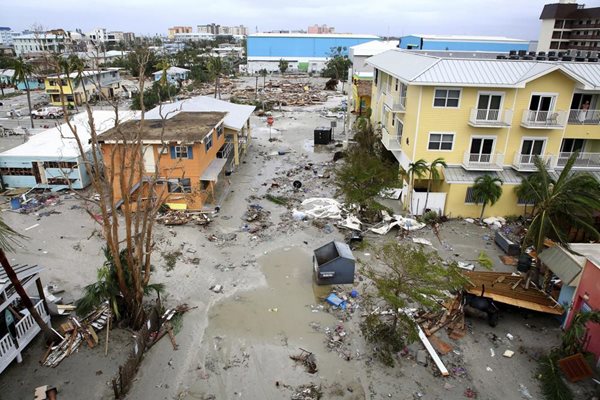
Ian had come ashore Wednesday on Florida’s Gulf Coast as a monstrous Category 4 hurricane, one of the strongest storms ever to hit the U.S. It flooded homes on both the state’s coasts, cut off the only road access to a barrier island, and destroyed a historic waterfront pier.
PHOTO: Damaged homes and businesses are seen in Fort Myers Beach, Fla., on Thursday, Sep 29, 2022, following Hurricane Ian. (Douglas R. Clifford/Tampa Bay Times via AP)
THURSDAY 5 PM:
Ian has re-intensified into a hurricane again.
After it came ashore Wednesday at Fort Meyers Beach as a devastating category 4, and continued across Florida with 70-mph winds, it went back to sea Thursday morning near Cape Canaveral.
Since then, the time over more warm ocean waters has revved up Ian back to a Category 1 hurricane with 75 mph winds.
It's on track for another landfall, this time forecast for Friday afternoon at Charleston, South Carolina.
THURSDAY 5 AM:
Hurricane Ian left a path of destruction in southwest Florida, trapping people in flooded homes, damaging the roof of a hospital intensive care unit and knocking out power to 2.5 million people before aiming for the Atlantic Coast on Thursday.
One of the strongest hurricanes to ever hit the United States churned across the Florida peninsula, threatening catastrophic flooding inland. Ian’s tropical-storm-force winds extended outward up to 415 miles, and nearly the entire state was getting drenched.
The National Hurricane Center said Ian became a tropical storm over land early Thursday and was expected to regain near-hurricane strength after emerging over Atlantic waters near the Kennedy Space Center later in the day. Flooding rains continued across the state, and a stretch of the Gulf Coast remained inundated by ocean water, pushed ashore by the massive storm.
“Severe and life-threatening storm surge inundation of 8 to 10 feet above ground level along with destructive waves is ongoing along the southwest Florida coastline from Englewood to Bonita Beach, including Charlotte Harbor,” the center said.
In Port Charlotte, along Florida’s Gulf Coast, the storm surge flooded a lower-level emergency room in a hospital even as fierce winds ripped away part of the roof from its intensive care unit, according to a doctor who works there.
Law enforcement officials in nearby Fort Myers received calls from people trapped in flooded homes or from worried relatives. Pleas were also posted on social media sites, some with video showing debris-covered water sloshing toward homes’ eaves.
Hurricane Ian turned streets into rivers and blew down trees as it slammed into southwest Florida on Wednesday with 150 mph winds, pushing a wall of storm surge. Ian’s strength at landfall was Category 4 and tied it for the fifth-strongest hurricane, when measured by wind speed, to ever strike the U.S.
Ian dropped to a tropical storm early Thursday over land, but was expected to intensify again once its center moves over the Atlantic Ocean and menace the South Carolina coast Friday at near-hurricane strength. Storm surges as high as 6 feet were expected on both sides of the peninsula.
At 5 a.m. Thursday, the storm was about 40 miles southeast of Orlando and 35 miles southwest of Cape Canaveral, carrying maximum sustained winds of 65 mph and moving toward the cape at 8 mph, the Miami-based hurricane center said.
Hurricane warnings were lowered to tropical storm warnings across the Florida peninsula, with widespread, catastrophic flooding remaining likely, the hurricane center said.
Up to a foot of rain forecast for parts of Northeast Florida, coastal Georgia and the Lowcountry of South Carolina. As much as 6 inches could fall in southern Virginia as the storm moves inland over the Carolinas, and the center said landslides were possible in the southern Appalachian mountains.
No deaths were reported in the United States from Ian by late Wednesday. But a boat carrying Cuban migrants sank Wednesday in stormy weather east of Key West.
Zuram Rodriguez surveys the damage around her mobile home in Davie, Fla., early Wednesday, Sept. 28, 2022. Hurricane Ian rapidly intensified off Florida's southwest coast Wednesday morning, gaining top winds of 155 mph, just shy of the most dangerous Category 5 status. (Joe Cavaretta/South Florida Sun-Sentinel via AP)
Advertisement
Hurricane Ian bears down on South Carolina today
Advertisement
Latest State & National
State & National
9 hours ago

State & National
20 hours ago

State & National
yesterday

State & National
yesterday

State & National
yesterday

ADVERTISEMENT
Most Read >
ADVERTISEMENT
Latest State & National
State & National
9 hours ago
State & National
20 hours ago
State & National
yesterday
State & National
yesterday
State & National
yesterday
Advertisement
ADVERTISEMENT