While everyone is enjoying the cooler temperatures this week, many are hoping for any amount of measurable rain to fall soon.
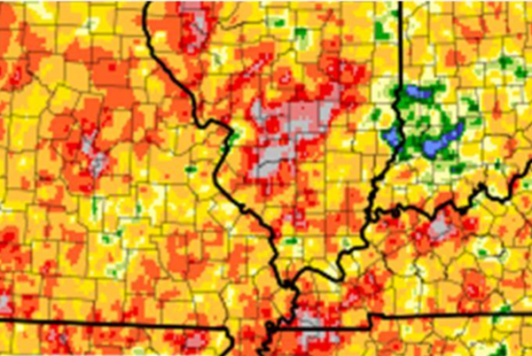
The latest map from the National Weather Service office in Paducah shows that some parts of the region have received practically no rain in August.
After our extremely wet spring/early summer, the faucet abruptly turned off once we hit the last week of July.
On the attached map, the gray areas are driest and the blue are wettest. Most areas have seen less than 25 percent of their normal amounts for August.
Carbondale has received only .02 inches of precipitation this month. If that holds out for the last few days of the month, they'll shatter their record low of .35 inches set in 1936. Normal August rainfall is around 3 to 3.5”.
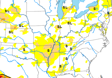
The dry summer has also brought drought conditions to parts of our region since June.
The USDA's drought monitor as of August 21 shows the Missouri Bootheel, westernmost Tennessee and the western Kentucky counties of Fulton, Hickman and Carlisle to be in D-1 moderate drought. All of the rest of western Kentucky and most of southern Illinois are classed as D-0 abnormally dry.
Advertisement
After spring soaking, a parched summer brings first stages of drought to our region
Advertisement
Latest Local & Regional
Local & Regional
31 minutes ago

Local & Regional
an hour ago

Local & Regional
an hour ago

Local & Regional
2 hours ago

Local & Regional
3 hours ago

ADVERTISEMENT
Most Read >
ADVERTISEMENT
Latest Local & Regional
Local & Regional
31 minutes ago
Local & Regional
an hour ago
Local & Regional
an hour ago
Local & Regional
2 hours ago
Local & Regional
3 hours ago
Advertisement
ADVERTISEMENT