
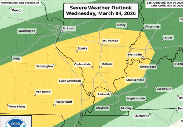
The National Weather Service in Paducah has issued a severe thunderstorm watch until 9 p.m. for all of southern Illinois, southeast Missouri and the western Kentucky counties bordering the Mississippi and Ohio rivers.
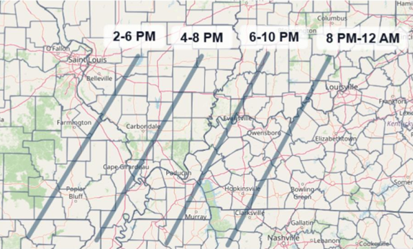
Clusters and line segments of strong to severe thunderstorms will move through the area this afternoon and evening. The timing for western Kentucky for primary risk will be now through 8 pm, but additional non-severe thunderstorms are forecast through the night.
Damaging wind gusts and large hail will be the main threats, but a brief tornado cannot be ruled in out southeast
Missouri and southwest Illinois. Locally heavy rain is expected as well.
On and off chances for thunderstorms will continue Thursday through Tuesday. A few strong to severe thunderstorms are possible late Friday night for southeast Missouri, southern Illinois, and portions of southwest Indiana. Damaging winds, large hail, and a brief tornado would the main threats.
Today's severe thunderstorm watch is the first issued this year in the U.S. since Novermber, a 101-day stretch. That's the longest interval without a severe thunderstorm watch since 2015.
Advertisement
Severe thunderstorm watch issued until 9 PM
Advertisement
Latest Local & Regional
Local & Regional
an hour ago
Local & Regional
an hour ago
Local & Regional
5 hours ago

Local & Regional
6 hours ago

Local & Regional
7 hours ago

ADVERTISEMENT
Most Read >
ADVERTISEMENT
Latest Local & Regional
Local & Regional
an hour ago
Local & Regional
an hour ago
Local & Regional
5 hours ago
Local & Regional
6 hours ago
Local & Regional
7 hours ago
Advertisement
ADVERTISEMENT