
Numerous high and warm minimum temperature records will continue to be broken through the weekend. Some locations may hit 70 every day through Sunday, while others reach well into the 60s.
Persistent cloud cover with periods of drizzle or light rain will continue over much of the region on Christmas Day and possibly through Friday in portions of the Evansville Tri State and western Kentucky.
On Sunday night, a strong cold front will bring an abrupt end to the warmth. Rain and a few thunderstorms are likely Sunday, a few of which could be strong.
A brief blast of cold air arrives early next week with highs struggling to reach freezing and lows falling into the upper teens to lower 20s.
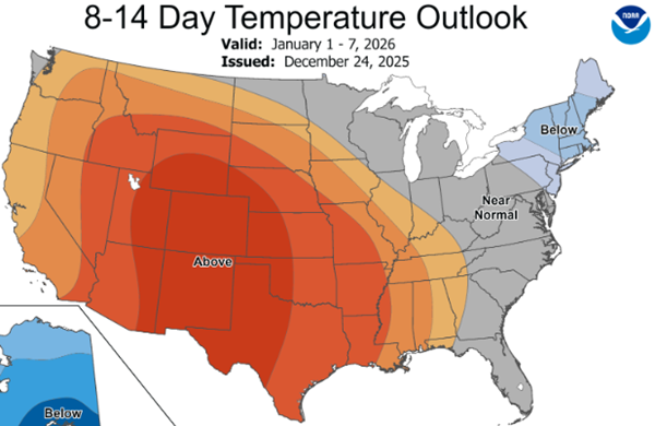
A look at the 8-14 day outlook map shows above normal temperatures returning to the lower Ohio Valley for the first week of the new year. Paducah's average high temperature that week is 45 degrees.
Advertisement
Brief dip to freezing after record warmth
Advertisement
Latest Local & Regional
Local & Regional
an hour ago

Local & Regional
an hour ago
Local & Regional
8 hours ago

Local & Regional
20 hours ago

Local & Regional
22 hours ago
.png?lang=en-US&width=600&height=388&ext=.png)
ADVERTISEMENT
Most Read >
ADVERTISEMENT
Latest Local & Regional
Local & Regional
an hour ago
Local & Regional
an hour ago
Local & Regional
8 hours ago
Local & Regional
20 hours ago
Local & Regional
22 hours ago
Advertisement
ADVERTISEMENT